Scientists from the University of Arizona, the U.S. Department of Energy's Brookhaven National Laboratory, and the Smithsonian Institution have used carbon-dating technology to determine the age of a controversial parchment that might be the first-ever map of North America. In a paper to be published in the August 2002 issue of the journal Radiocarbon , the scientists conclude that the so-called "Vinland Map" parchment dates to approximately 1434 A.D., or nearly 60 years before Christopher Columbus set foot in the West Indies.
"Many scholars have agreed that if the Vinland Map is authentic, it is the first known cartographic representation of North America, and its date would be key in establishing the history of European knowledge of the lands bordering the western Atlantic Ocean," said chemist Garman Harbottle, the lead Brookhaven researcher on the project. "If it is, in fact, a forgery, then the forger was surely one of the most skillful criminals ever to pursue that line of work."
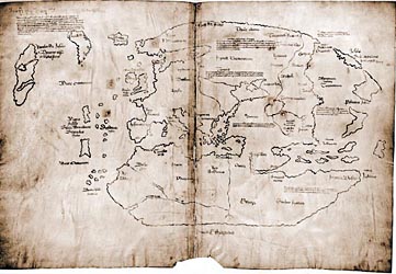
Housed in Yale University's Beinecke Rare Book and Manuscript Library, the map shows Europe (including Scandinavia), Northern Africa, Asia and the Far East, all of which were known by 15th-century travelers. In the northwest Atlantic Ocean, however, it also shows the "Island of Vinland," which has been taken to represent an unknown part of present-day Labrador, Newfoundland, or Baffin Island. Text on the map reads, in part, "By God's will, after a long voyage from the island of Greenland to the south toward the most distant remaining parts of the western ocean sea, sailing southward amidst the ice, the companions Bjarni and Leif Eiriksson discovered a new land, extremely fertile and even having vines, ... which island they named Vinland."
The map, drawn in ink and measuring 27.8 x 41.0 centimeters, surfaced in Europe in the mid-1950s, but had no distinct record of prior ownership or provenance in any famous library. The map and the accompanying "Tartar Relation," a manuscript of undoubted authenticity that was at some point bound with the Vinland Map in book form, were purchased in 1958 for $1 million by Paul A. Mellon, known for his many important gifts to Yale, and, at Mellon's request, subjected to an exhaustive six-year investigation.
In 1965 the Yale University Press published "The Vinland Map and the Tartar Relation," a detailed study by R.A. Skelton, T. E. Marston and G. D. Painter that firmly argued for the map's authenticity, connecting it with the Catholic Church's Council of Basel (A.D. 1431-1449), which was convened a half-century before Columbus's voyage. Two scientific conferences, in 1966 and 1996, featured strong debates over the map's authenticity, but no final determination could be made based on the available facts.
Beginning in 1995, Harbottle, along with Douglas J. Donahue, University of Arizona, and Jacqueline S. Olin, Smithsonian Center for Materials Research and Education, undertook a detailed scientific study of the parchment. The scientists traveled to Yale, where they were allowed to trim a 3-inch-long sliver off the bottom edge of the parchment for analysis. Using the National Science Foundation-University of Arizona's Accelerator Mass Spectrometer, the scientists determined a precision date of 1434 A.D. plus or minus 11 years. The unusually high precision of the date was possible because the parchment's date fell in a very favorable region of the carbon-14 dating calibration curve. This new analysis of the map parchment reaffirms the association with the Council of Basel since it dates exactly to that time period, and makes a strong case for the map's authenticity.
Several previous studies challenging the map's authenticity have focused on the chemical composition of the ink used to draw it. Some initial work found anatase, a particular form of titanium dioxide, in the ink. Since anatase only went into commercial production in the 20th century, some concluded that the ink was also a 20th-century product, making the map a forgery. Recent testing, however, only revealed trace quantities of titanium, whose presence may be a result of contamination, the chemical deterioration of the ink over the centuries, or may even have been present naturally in the ink used in medieval times. Another recent study detected carbon, which has also has been presented as evidence of a forgery. However, carbon can also be found in medieval ink. Current carbon-dating technology does not permit the dating of samples as small as the actual ink lines on the map.
"While the date result itself cannot prove that the map is authentic, it is an important piece of new evidence that must be considered by those who argue that the map is a forgery and without cartographic merit," said Harbottle.
July 29, 2002 - Scientists determine age of first New World map; Parchment points to authenticity of Vinland Map
For the first time, scientists have ascribed a date -- 1434 A.D., plus or minus 11 years -- to the parchment of the controversial Vinland Map, possibly the first map of the North American continent. Collaborators from the Smithsonian Center for Materials Research and Education (SCMRE), Suitland, Md., the University of Arizona, Tucson, and the U.S. Department of Energy's Brookhaven National Laboratory, Upton, N.Y., used carbon-dating techniques to analyze the parchment on which the map is drawn. Their findings, published in the August edition of the journal Radiocarbon, place the parchment of the map 60 years ahead of Christopher Columbus' arrival in the West Indies, and provide compelling evidence that the map is authentic.
"Many scholars have agreed that if the Vinland Map is authentic, it is the first cartographic representation of North America, and its date would be key in establishing the history of European knowledge of the lands bordering the western Atlantic Ocean," said Jacqueline S. Olin, assistant director for archaeometric research at SCMRE when the study began in 1995. Olin and co-authors Douglas Donahue, a physicist at the University of Arizona and Garman Harbottle, a chemist at Brookhaven National Laboratory, along with SCMRE paper conservator Dianne Van Der Reyden, sampled the bottom right edge of the parchment for analysis. The dating was carried out at the National Science Foundation-University of Arizona Accelerator Mass Spectrometer in Tucson. The unusually high precision of the date was possible because the Vinland Map's date fell in a very favorable region of the carbon-14 dating calibration curve.
The parchment analysis again indicates the map's connection with the Catholic Church's Council of Basel, convened between 1431 and 1449, first posited by R.A. Skelton, T.E. Marston and G.D. Painter, the scholars who undertook a six-year investigation of the Vinland Map and accompanying "Tartar Relation," and made their argument for the map's authenticity in the book, The Vinland Map and the Tartar Relation, published in 1965 by Yale University Press. Paul A. Mellon had purchased the map and manuscript for $1 million in 1958, and requested the study after donating them to Yale.
The map came to light in Europe in the mid-1950s without any record of previous ownership or provenance in any library or collection. It is now in the collection of Yale's Beinecke Rare Book and Manuscript Library in New Haven, Conn. The name "Vinland" derives from text on the map that recounts Bjarni and Leif Eriksson discovering "a new land, extremely fertile and even having vines, " which island they named Vinland." The "Island of Vinland" appears on the map in the northwest Atlantic Ocean. Scholars postulate it may represent present-day Labrador, Newfoundland or Baffin Island. The map also shows Europe, Africa and Asia.
Several previous studies challenging the map's authenticity focused on the chemical composition of the ink used to draw it, and pointed to the presence of anatase, which was not produced commercially until the 20th century. But there are questions about how an ink containing anatase could have been formulated and used by a forger. More recently, the ink has been shown to contain carbon, which also has been presented as evidence of a forgery. However, carbon can be present in a medieval ink.
"Anatase may be a result of the chemical deterioration of the ink over the centuries, or may even have been present naturally in the ink used in medieval times," Olin said, adding, "The elemental composition of the ink is consistent with a medieval iron gall ink, based on historical evidence regarding ink production."
Present carbon-dating technology does not permit the analysis of samples as small as the actual ink lines on the map.
Concluded Olin, "While the date result itself cannot prove that the map is authentic, it is an important piece of new evidence that must be considered by those who argue that the map is a forgery and without cartographic merit."